火星上古老的奧岡奎特海灘
Ancient Ogunquit Beach on Mars
發表日期:2025-03-23
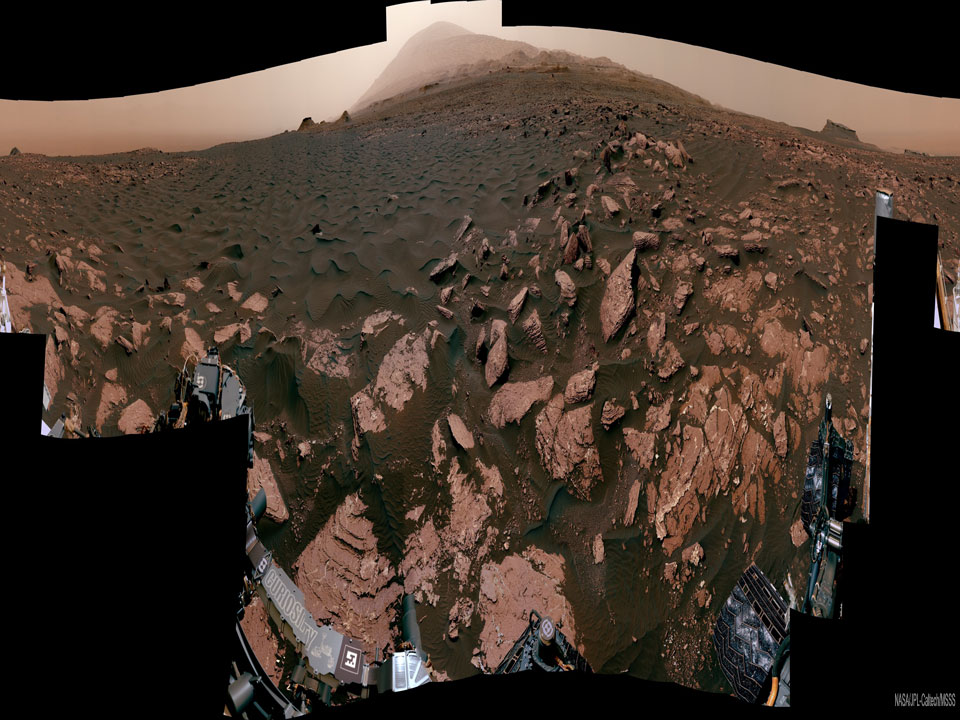
這裡曾經是一片海灘--在古老的火星上。這幅經過水平壓縮的 360 度全景圖是由探索這顆紅色星球的機器人 "好奇號 "漫遊車於 2017 年拍攝的。有證據顯示,在很久以前,該地區有時在水下,有時則在一個古代湖泊的邊緣。 中央背景中的淺色山峰是夏普山的山頂,它是好奇號探索蓋爾隕石坑的中心地帶。前景中的部分深色沙土被挖出進行分析。 淺色基岩由沉積物組成,很可能沉澱在現已乾涸的湖床底部。 特色全景圖(此處為互動版本)由 100 多張圖片拼接而成,左下方似乎有漫遊車的簽名。
原文:This was once a beach -- on ancient Mars. The featured 360-degree panorama, horizontally compressed, was taken in 2017 by the robotic Curiosity rover that explored the red planet. Named Ogunquit Beach after its terrestrial counterpart, evidence shows that at times long ago the area was underwater, while at other times it was at the edge of an ancient lake. The light peak in the central background is the top of Mount Sharp, the central feature in Gale Crater where Curiosity explored. Portions of the dark sands in the foreground were scooped up for analysis. The light colored bedrock is composed of sediment that likely settled at the bottom of the now-dried lakebed. The featured panorama (interactive version here) was created from over 100 images and seemingly signed by the rover on the lower left.
※ 本文由萌芽機器人自動轉貼自每日一天文圖(Astronomy Picture of the Day,APOD),原文為英文,正體中文是透過 DeepL 翻譯及 OpenCC 進行自動處理,內容僅供參考,若有任何錯誤之處還請見諒!
關於每日一天文圖:每日一天文圖網站是美國國家航空暨太空總署與密西根理工大學提供的服務,網站每天提供一張影像或圖片,並由天文學家撰寫扼要說明其特別之處。