德克薩斯州上空的風暴雲
Storm Cloud Over Texas
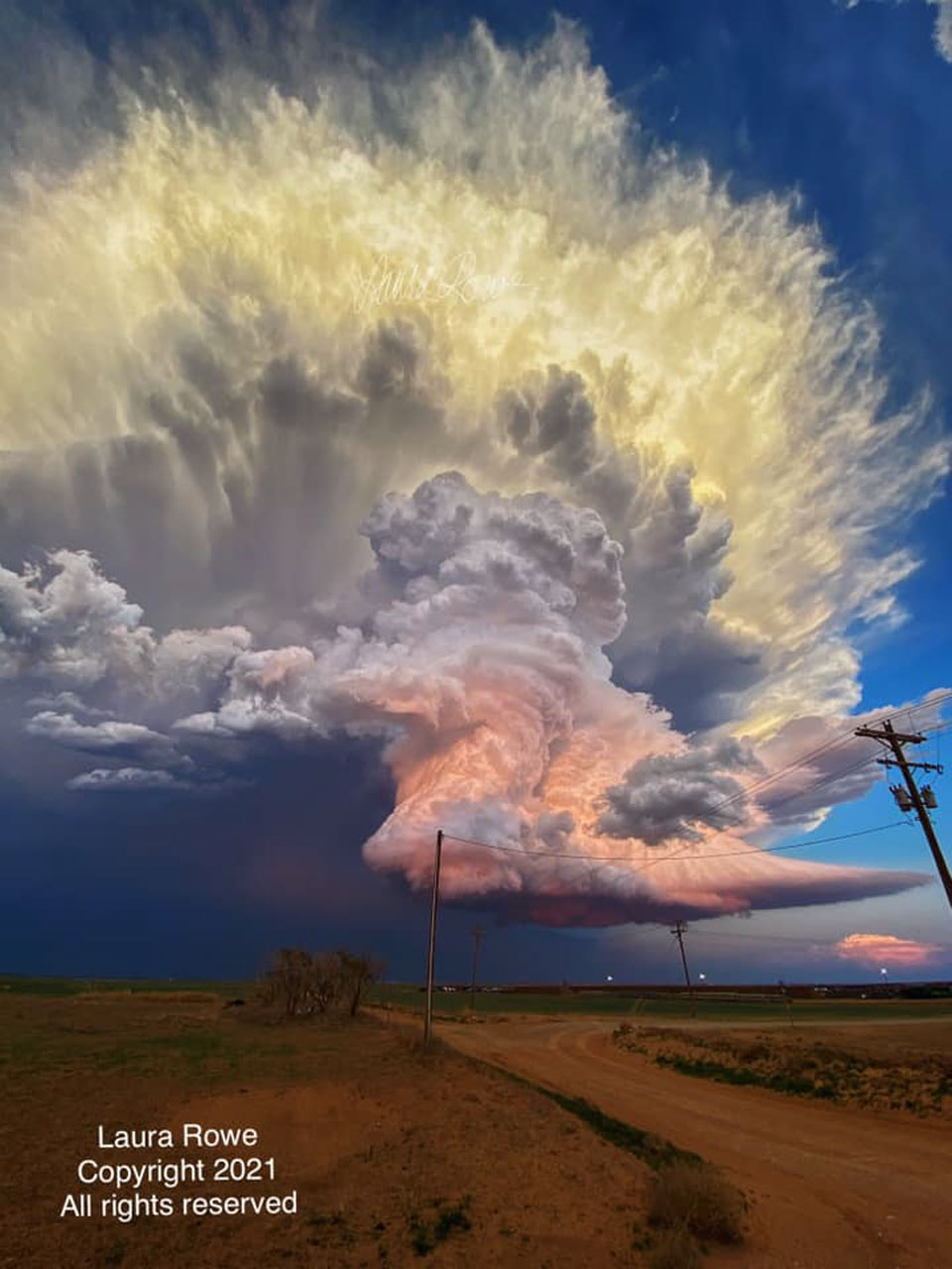
來源:Laura Rowe (Used with permission)|發表日期:2024-08-06
是什麼讓這朵暴風雲如此多姿多彩? 首先,雲本身是由數百萬個微小的水滴和冰滴組成的。 它的底部幾乎完全是平的--但這並不罕見。 雲底平坦一般是由於空氣溫度隨著高度上升而下降,在特定高度以上,飽和的空氣會凝結出水滴。 雲中間的形狀是由含水滴的氣柱向上吹造成的。 最特別的是橙色和黃色。 這兩種顏色都是由雲中的水滴反射陽光造成的。雲中間和底部的橙色是近似紅色夕陽的反射。 與此相反,雲頂部的黃色是由於太陽尚未落山時的反射光造成的,其中一些(但較少)藍光被散射掉了。這幅令人印象深刻的動態積雨雲影像於 2021 年在德克薩斯州的平原上拍攝,當時正在調查一場龍捲風。
原文:What makes this storm cloud so colorful? First, the cloud itself is composed of millions of tiny droplets of water and ice. Its bottom is almost completely flat -- but this isn't unusual. Bottom flatness in clouds is generally caused by air temperature dropping as you go up, and that above a specific height, water-saturated air condenses out water droplets. The shape of the cloud middle is caused by a water-droplet-laden column of air being blown upward. Most unusual, though, are the orange and yellow colors. Both colors are caused by the cloud's water drops reflecting sunlight. The orange color in the cloud's middle and bottom sections are reflections of a nearly red sunset. In contrast, the yellow color of the cloud's top results from reflection of light from a not-yet-setting Sun, where some -- but less -- blue light is being scattered away. Appearing to float above the plains in Texas, the featured impressive image of a dynamic cumulonimbus cloud was captured in 2021 while investigating a tornado.
※ 本文由萌芽機器人自動轉貼自每日一天文圖(Astronomy Picture of the Day,APOD),原文為英文,正體中文是透過 DeepL 翻譯及 OpenCC 進行自動處理,內容僅供參考,若有任何錯誤之處還請見諒!
關於每日一天文圖:每日一天文圖網站是美國國家航空暨太空總署與密西根理工大學提供的服務,網站每天提供一張影像或圖片,並由天文學家撰寫扼要說明其特別之處。